Cooking up Amazing Trips contains affiliate links. If you purchase through these links, I may earn a commission at no extra cost to you. See my Disclosure Policy for more information. Thanks for supporting my blog!
Pinto: The Geographic Centre of Spain
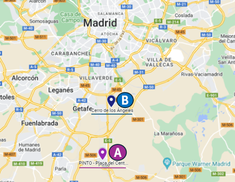
Where is the geographic centre of Spain? Pinto or Getafe?
Allow me to explain the reasons behind each position so you can judge yourself.
There is no question about the geographic centre of Peninsular Spain being located in the Community of Madrid. The dispute comes as to which municipal area holds the title.
There are two theories:
- 🅰️ Pinto
- 🅱️ Cerro de los Angeles (Getafe)

A. Pinto as the Geographic Centre of Spain
This theory is based on several hypotheses:
1️⃣ Due to the Roman origin of the settlement and its name, which comes from the Latin “Punctum,” meaning point.
2️⃣ The second hypothesis dates back to the 8th century when the Arabs conquered the Peninsula. After conducting their research, they concluded that Pinto was the centre.
According to legend, Muslims buried an ark at that location with the tools they used for measuring.
Until the last century, there was a circular stone in Pinto marked with a cross named “La Exacta” (The exact one), designating that specific point.
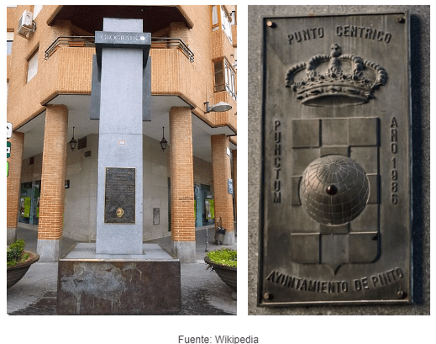
In its current location, there is a monolith between Hospital and Maestra María del Rosario streets, which, until 1935, was formerly known as Calle del Arca (Ark Street).

3️⃣ In 1560, King Philip II commissioned Pedro de Esquivel, a professor, mathematician, and cosmographer, to create a map of Spain.
Using geodetic triangulation, he located the Peninsula’s central point in Pinto.
In 1561, Madrid became the first permanent capital of the Spanish monarchy when Philip II relocated the court there.
4️⃣ During the 16th and 17th centuries, many written references identified the town of Pinto as the centre of the Iberian Peninsula.
Some of these authors are Pérez de Herrera (1597), Maldonado de Matute (1600), Jerónimo Quintana (1629), Núñez de Castro (1658), Paul L. Berkenmeyer (1729), Juan Antonio de Estrada (1746), Antonio Moya (1756) and Ramón de la Cruz (18th century).
5️⃣ In addition, the coat of arms of the town of Pinto, which dates back to the 16th century, features a globe with a red dot marking the centre of the Peninsula.

B. Cerro de los Ángeles as the Geographic Centre

According to the people of Getafe, the Cerro de los Ángeles is the centre. Due to its high altitude, the place’s strategic location led Alfonso VI to build a hermitage at the summit in 1085.
But the dispute originated at the beginning of the 20th century, when deputy governor of the Bank of Spain, Francisco Belda, suggested that Cerro de los Ángeles would be a fitting location for a National Monument to the Sacred Heart of Jesus. One of his reasons for this choice was that it is the geographic centre of the Peninsula. He used the intersection of two diametrical lines drawn from Cape Ortegal to Palos and Creus to Espichel.

In 1919, Alfonso XIII unveiled a statue of the Sacred Heart. Later, in 1965, Franco inaugurated the current monument, commonly referred to as the Peninsular Center, due to its religious symbolism and the regime’s support for it. It is also considered the spiritual centre of Spain.
Finding a solution to this conflict is challenging, as even the National Geographic Institute admits that determining the precise location of Spain’s geographical centre is complicated and depends on the methodology used.
In short, the current position leans towards Cerro de los Ángeles as the centre of Spain for political and religious reasons. However, in the past, history attributed it to Pinto.
Which theory do you find more convincing: the one based on history or the one based on politics and religion? I’m curious to hear your thoughts!
Other Interesting Posts About Madrid
If you would like to know more about Madrid, read my article 10 Curious Things about Madrid. Or, if culture is more your thing, I’d recommend my post, 10 Historical Moments that Changed Madrid.
Are you considering visiting Spain’s capital? See my 3-day Madrid Itinerary (by a local).
I hope you liked this post about Pinto and the geographic centre of Spain.
Ready to Book your Trip?
To help you organise your adventure, I’ve gathered the best tools I use and recommend for booking flights, hotels, local transport and more. These links support this site at no extra cost to you.
🧳 Book Your Trip Here
- ✈️ Flights: Compare the best prices on flights using Kayak.
- 🛏️ Accommodation: Find hotels and unique stays at great prices worldwide with Booking.com.
- 🚐 Transfers: Pre-book your airport or city transfers to avoid stress on arrival with Welcome Pickups.
- 🚗 Car Rentals: Explore destinations at your own pace by using Discover Cars or Auto Europe to compare reliable car rental providers.
- 💺Transport (Bus and Train Tickets): Compare schedules and easily book intercity bus and train travel with Omio.
- 📷 Tours & Activities: Book fun experiences, guided tours, and skip-the-line tickets in advance with GetYourGuide or Viator.
- 🌐 Internet Connection: Stay connected abroad with eSIMS from Airalo.
Safe travels! 🌏✈️
Additional Information
You can also check my itineraries in Itineraries. Here, you’ll find them classified in City Guides and Country Guides.
Alternatively, in the section Destinations, they are classified based on the type of trip:
- Amazing Experiences. It covers the most extensive and complete trips.
- Beach and Sea. For those who prefer quieter activities by the sea.
- City Breaks. Short trips with a single destination.
📌 If you prefer to see them separated by continents, check them in Portfolios.
Remember to check Cook up Your Trip. There, you will find everything you need to organise your trip from start to finish.
If you need any clarification, please don’t hesitate to contact me. You can leave a comment below or fill out the contact form, and I’ll gladly assist you.😊


